

Some notes on the London place name shortage
Also: how the north-south divide has left much of this country trailing East Germany, without half a century of communist rule to blame for it.

When I was a kid, growing up somewhere in the badlands of zone 6, I didn’t often get to see proper London. Sure, there were occasional trips – I have dim memories of my paternal grandmother Ollie1, who only died just over a year ago, aged 95, deciding one day to entertain her five year old grandson by taking me to climb the 311 steps of the Monument. But for the most part my sense of the capital came largely from the tube map and the A to Z.
That meant it came largely from place names, but this wasn’t a problem, because London is brilliant for place names. There were the famously evocative names of tube stations – Elephant & Castle, Shepherd’s Bush, Swiss Cottage, Chalk Farm – which we’ve all grown so used to that it’s easy to lose sight of the fact they sound like bits of fairy tales. Then there are those places which didn’t make it onto the tube map, at least in those days, but which are just as lovely: Poultry, Primrose Hill, Pratts Bottom; Fish Island, Fitzrovia and Freezywater; Eel Pie Island or Maze Hill, Tokyngton and Temple Fortune. Hidden London’s London Gazetteer contains 821 entries. I can tell, by sight, that it hasn’t even scratched the surface.
This is hardly unique to the capital. Not every city is great for names, but many are, and there’s probably an equation waiting to be discovered, in which you can estimate the number of place names in a town using its population and physical size and the length of time it’s been standing there, plus, perhaps, the diversity of its population and/or number of times it’s changed hands. (After all, Istanbul, where once you’d have found Justinian the Great plotting his next campaign, is on its third name.)
So perhaps when a city has nearly 10 million people in it, and it’s been there for 2,000 years, and the patch of land 20 or 30 miles wide that contains it was previously the home to untold dozens of towns and villages that existed long before the city swallowed them – perhaps then, it’s inevitable that it builds up enough names that some of them start to repeat. Perhaps London has more places than there are names to apply to them.

The one that annoyed me growing up was Bromley. Growing up on the far end of the District line, just past Vladivostok East, the Bromley I was most aware of was the one with -by-Bow at the end of its name, because it’s a station on that very line. The centuries’ old suffix seems to be added to distinguish it from the other Bromley, eight miles south in what used to be Kent. The latter is definitely bigger, but the former was on the tube map, so really, who’s to say which was better known to the average Londoner.
The Bow in “-by-Bow”, incidentally, lies slightly to the north of Bromley-by-Bow and takes its name from a long forgotten bow-shaped bridge over the River Lea. It was once called Stratford-atte-Bow, to distinguish it from the area we still call Stratford, on the other side of the river: that was then known variously as Stratford Abbie, Stratford Langthorne or Stratford Hamme, because it was the home to Langthorne Abbey in the parish of West Ham, and because having two neighbouring villages with the same name was inconvenient. Why were they both called Stratford? Because they were either side of a ford, on a Roman (“straight”) road, which is why a lot of places were called Stratford.
At any rate, the problem of repeated place names is neither new, nor unique to London. But because modern London is quite big, it happens quite a lot here. Just to the north of the Bromley that used to be in Kent you’ll find Plaistow; you’ll find a different Plaistow just to the east of the one by Bow, in what used to be Essex. There’s a Hayes near the Kentish Bromley, too, not to be confused with the Hayes someway to the west in what used to be Middlesex. You might confuse them, too, because they both have stations: Hayes & Harlington for the one in Hillingdon (Middlesex), simply Hayes for the one in Bromley (Kent).
At least they have different names. The St Margarets station between Richmond and Twickenham, and the one on the Hertford East branch, don’t, despite serving radically different bits of the London commuter market. There are two Rainham stations, too, one on the Fenchurch Street line where London turns to Essex, one across the river and a few miles east in the Medway towns. The St Johns station in Lewisham has nothing to do with the St John’s Wood one behind Regent’s Park. And Barkingside is a good four miles north of Barking (though the names do at least seem to be related; the former was on the Barking side of Hainault Forest).
I could go on like this. London has two Church Ends, two Coombes, two Grove Parks, and two Belmonts. There’s a Barnes and a Barnes Cray, both Thames-side suburbs, but 20 miles apart. There are those places which clearly are related, but have names and locations close enough to one another to cause confusion: Bexley and Bexleyheath, Becontree and Becontree Heath, Leyton and Leytonstone, or the numerous places called Barnet.
And this is just area names: if you dig down to the level of location or street, things repeat all the more. The London Streets section of streetmap.co.uk covers not just London, but the inner ring of commuter towns (and there is absolutely no way I’m going through those lists to work out which are actually inside the city’s fairly arbitrary official limits, sorry). That includes 165 High Streets, 15 Broadways and 30 The Broadways. I tried doing the same for the other names which a 2004 report from the Halifax building society claimed were the most popular street names in London – Church Road, Park Road, The Avenue, The Drive. I swear I am not lying when I tell you the search engine gave up in disgust.
The second most annoying thing about all this is the ridiculous profusion of places – Victoria Park, Victoria Street, Victoria station, Royal Victoria Dock – named after a long-reigning 19th century queen.
The most annoying thing, though, is the knowledge that the Elizabeth Line and Queen Elizabeth Olympic Park will one day be just the tip of the iceberg of things that are inevitably going to be named after an even longer-reigning 20th/21st century one.
Actually, that is a lie. The really annoying thing for me personally is the existence of two separate stations named Bethnal Green, because I live near them. Sort it out, TfL.
Chart of the week
I try not to let this newsletter get too London centric, because, as the internet is always delighted to remind anyone who ever writes about the capital, not everyone lives in London. So to balance things out a bit here’s one of the most telling – I don’t want to say “favourite”, for reasons that are about to become clear – charts about the rest of the country.

This baby comes courtesy of Imactivate, the software/data/consultancy thing run by Twitter’s favourite professional Yorkshireman Tom Forth. It shows the GDP per head, expressed in purchasing power, as a percentage of the EU average in Germany (the red line on the top) and the five states that formed part of East Germany (the five coloured lines on the bottom).
And what it shows is that Germany as a whole is substantially richer than the EU average, and became even more so after the financial crisis; while the former East German states are substantially poorer than the EU average but, especially after the financial crisis, closed much of the gap. That may be good economic management in Germany, at work; or it may be the result of a Eurozone largely run in Germany’s interests. Take your pick.
It’s not Germany I’m actually interested in, though: I’m just using it as a comparator. What I’m actually interested in is this:
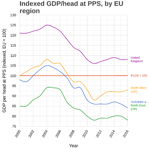
That’s the same graph, only this time showing the UK (the mauve line on the top) and the three regions that make up the north of England (the three coloured lines on the bottom).
That shows that the UK began the century substantially richer than the EU average, but failed to keep track, until by 2016 – where do I recognise that date from? – it was only a little bit richer. The three northern regions followed roughly the same pattern, albeit with a more pronounced boom around 2004-6, but started much lower and ended lower still. Yorkshire & the Humber went from being a little bit poorer than the EU average in 2000 – a pretty shocking stat in itself – to nearly 15% poorer by the time of the referendum. Then the data stops.
To really hammer it home, here’s Yorkshire – the middle ranked of the three northern regions – against the East German states:

In 2000, Yorkshire was substantially richer than every East German state. By 2016, it was poorer than all of them.
And then we had a referendum.
The data stops in 2016. It is possible the picture has changed since. But it does seem worth noting that, this week, the government released a 108 page report on the benefits of Brexit. The subject of GDP growth didn’t come up.
Self-promotion corner
This is an edited extract from the Newsletter of (Not Quite) Everything, which goes out every Wednesday at 4pm. In this week’s edition I wrote about how, no, religious people have not been barred from public life, don’t be silly. Also, some adverts I really hope they wouldn’t make now; and a map of eel(?) rents(?!?).
If you’re enjoying these weekly extracts, then why not become a paying supporter? For a mere £4 a month or £40 a year, and every Wednesday afternoon you’ll get a bit on politics, some diverting links, an article on something from history/geography/language/whatever I’ve been obsessing about this week, and the map of the week. And for less than a pound a week, too! Click here to get started.
BUT: we’re all broke right now. If you can’t currently justify paying for some nerd’s substack (unemployed, underemployed, impoverished student, and so forth), just hit reply and I’ll give you a complimentary subscription, no questions asked. I am literally giving it away.
Or here are some things you can read now, for free:
This piece about how Clarkson’s Farm is an unlikely YIMBY charter.
This one about the Northern Ireland Protocol, the Corn Laws and the Schleswig-Holstein Question (no, really).
A lot of nonsense I’ve written about Doctor Who, which you can find here.
Short for Alwynne. She was Cumbrian.