The fact contained in that headline is something people say to me, surprisingly frequently. I am often to be found charming and delighting people on Twitter, at parties and so on, by regaling them with surprising geographic facts. And every time I do, someone – normally quite a lot of someones – replies with: “Edinburgh is west of Bristol.”
And it is. Bristol is located at 2°35′ west; Edinburgh at 3°11′ west. This is surprising because Edinburgh is only a few miles from the east coast, and served by the East Coast Main Line, while Bristol is in the West of England. This island is on a lean.
But nonetheless, I am so bored by that fact. I am so bored with hearing it, over and over again. And since the only other option was to stop announcing surprising geographic facts to strangers, which I’m clearly not going to do, I thought I’d provide some alternatives.
1. The westernmost point of the island of Great Britain is Corrachadh Mòr in what was once Argyllshire and is now the Highland council area, at 6°13′ west. This is around a kilometre south of the lighthouse at Ardnamurchan Point, and around 735km north of Land’s End, the westernmost point in Cornwall. I’d foolishly assumed the latter to hold the record for westernmost point in Britain, since it’s the sticky out bit, but which turns out to be only 5°42′ west. Huh, the things you learn.
2. There are only three counties between Yorkshire and Kent.
3. Peterborough is only about six miles closer to London than it is to Hull. It’s only about nine miles closer than that to Norwich.
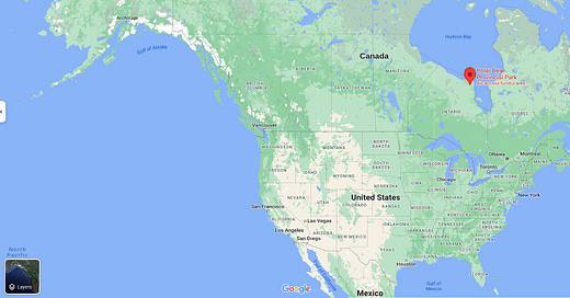
4. There’s a place in Ontario, on the shores of Hudson Bay, called Polar Bear Provincial Park. Head directly east from there, and you will end up in Lancashire.
5. A majority of Canadians live south of Lyon or Milan, cities I think of as not that far from the warm climes of the Med. That’s because...
6. …the vast majority of Canadians, more like 90%, live within 100 miles of the US border, and there’s a huge chunk of Ontario and Quebec which extends up to 750km farther south of the long straight line we tend to associate with the border. This area includes the country’s two largest cities, Toronto and Montreal.
A helpful aide to some of these entries. Image: Google Maps.
Part of that area is the stretch of land between Lakes Erie and Huron, which means...
7. If you drive south from Detroit, you will find yourself in Canada.
8. The southernmost bits of Canada are south of the northernmost bits of California.
(A lot of these are about how far south Canada/how good the Gulf Stream is, aren’t they? Let’s try something else.)
9. France’s longest border with a single other country is technically the one with (this’ll throw you) Brazil. This is due to the existence of French Guiana, a remnant of the empire, a chunk of South America slightly smaller than Portugal.
10. Africa is the only continent extending into all four hemispheres.
11. Invercargill, the southernmost city in New Zealand, lies at 46°24′ south; Whangārei, the northernmost, is at 35°43′. Transpose those latitudes to the old world, and New Zealand would stretch from roughly the middle of France to the middle of Tunisia. Europe is way farther from the equator than you imagine it to be.
12. Alaska contains both the US’s western- and easternmost points. (Okay that one’s cheating: it’s only true because the Aleutian island chain stretches across the meridian towards eastern Russia. But still.)
13. All of Florida is south of the US/Mexican border.
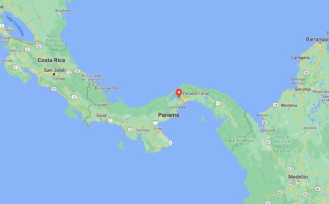
14. If you use the Panama Canal to cross from the Pacific Ocean, which lies to the west of the Americas, to the Atlantic Ocean, which lies to their east, you will be heading west. Seriously, check the map:
15. The northernmost point of Ireland is not in Northern Ireland.
16. The Sargasso Sea is the only sea in the world with no coasts. The reason it’s differentiated from the rest of the North Atlantic Ocean, by which it is surrounded, is because it’s full of Sargassum seaweed, which gets trapped there by four currents that form a sort of circle (the Gulf Stream to the west, North Atlantic Current to the north, Canary Current to the east, and North Atlantic Equatorial Current to the south).
17. The Istanbul version of Crossrail, the Marmaray – a 76.6km commuter rail tunnel named by combining the name of the Sea of Marmara (which lies a little to its south) and “ray”, the Turkish word for “rail” (which is what it is) – serves two different continents. Should you have the urge to take a metro from Europe to Asia, it’s just 3km and one stop between Sirkeci and Üsküdar.
Apparently you can now join me on Substack Notes?
I don’t really have any idea why you’d want to do that, but in case you do I’m posting stuff like this:
Here’s the blurb that Substack wrote for me in a shameless attempt to promote its Twitter clone:
“Notes is a new space on Substack for us to share links, short posts, quotes, photos, and more. I plan to use it for things that don’t fit in the newsletter, like work-in-progress or quick questions.”
“Head to substack.com/notes or find the “Notes” tab in the Substack app. As a subscriber to The Newsletter of (Not Quite) Everything, you’ll automatically see my notes. Feel free to like, reply, or share them around!
“You can also share notes of your own. I hope this becomes a space where every reader of The Newsletter of (Not Quite) Everything can share thoughts, ideas, and interesting quotes from the things we're reading on Substack and beyond.”
I’m not actually sure I do think that. But if you’d like to be on a thing that’s a bit like Twitter but much quieter and also not owned by Elon Musk, then Notes is there for you.
If you post your favourite thing I have written and tag me in some way I will probably “re-stack” it.
Right, that’s quite enough of that.
Map of the week
So, about this island being on a lean. Here’s a tweet that did the rounds recently, and did precisely what I’m assuming it was intended to, by winding everyone right up:
No, it turns out, we cannot all agree that places like Liverpool, Manchester and Sheffield are not in the north. Nor, as it turns out, is there any consensus about places like Peterborough or Norwich being in the Midlands. It does, though, give me a chance to resurrect one of my favourite theories, helpfully expressed by Map Man Jay Foreman here:
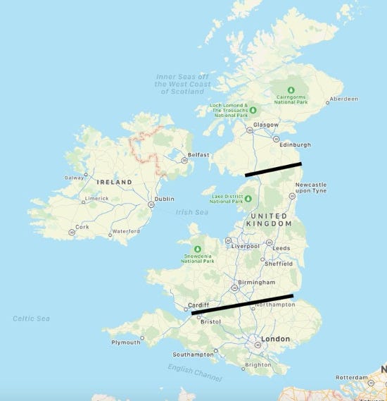
I’ve had the same thought myself (tweeted and written about it too, I think, though I can find no proof of that so if you want to imagine I’ve nicked it from Jay that’s your prerogative). In fact, I think we can go farther. Let’s annotate that map with two lines: one along the Scottish border, one between the Bristol Channel and the Wash (an oft-cited dividing line between the south and everything else):
They’re not quite level, but they’re much more level than they would be on an un-tilted map. (I considered adding a third, running along the northern edge of the M62 corridor – the division between the urban and rural north – but while that’s the most level of the lot I’m not sure it’s an identity divide in the same way.)
This does explain why we don’t think of southern Scotland as being on a level with Newcastle, even though it is; why we imagine Birmingham to be some way north of Norwich, even though it isn’t; even why we imagine Edinburgh to be east of Bristol when it isn’t. On some level, we’re correcting the map and imagining the east coast runs north-south rather on a lean.
I propose we call this “psychological north”.
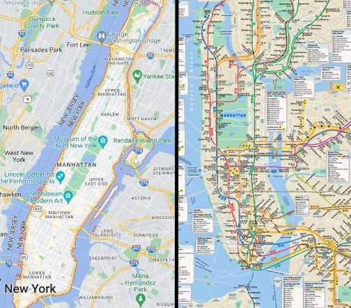
I very much doubt we’re the only place that has some version of this. The north of Manhattan lies significantly east of its south – but the subway map corrects this, so most New Yorkers, I suspect, imagine the avenues run north-south and the streets east-west.
Manhattan, as shown on Google Maps (left) and the MTA Subway map (right).
I wonder if there’s a similar thing in Italy, whose north, like that of Britain, is significantly west of its south? Please do write in.
Self-promotion corner
This is an extract from the archive of The Newsletter of (Not Quite) Everything, a newsletter (obviously) sent every Wednesday around 4pm. In this week’s edition In this week's edition, I wrote about Twitter, Substack, Elon Musk and the Streisand Effect; discussed a gif of the absurdity of English government; and asked: how many colours can a metro map cope with?
If you’re enjoying these weekly extracts from the archive, then why not become a paying supporter? Normally, for just £4 a month or £40 a year, every Wednesday afternoon you’ll get a bit on the news, some diverting links, an article on something from history/geography/language/whatever I’ve been obsessing about this week, and the map of the week. All for less than £1 a week.
But it gets better! Right now I’m running a special offer in which if you sign up for a year it’s just £38, and you get a copy of my book Conspiracy: A History of Bollocks Theories, and How Not To Fall For Them (co-written with the delightful Tom Phillips) when it comes out in paperback next month. Click here to get started.
All that, and your support with mildly annoy Elon Musk too!
That said, we’re all broke right now. If you can’t currently justify paying for some nerd’s substack (unemployed, underemployed, impoverished student, and so forth), just hit reply and I’ll give you a complimentary subscription, no questions asked. I am literally giving it away.


